Črna na Koroškem –> Etnographical collection –> Mining collection in Črna –> INFO point Geopark Karavanke and Beekiping craft–> Perkmandeljc –> Mining collection in Helena –> Monument of miner –> Entrance in the tunnel Helena –> Castles of king Matjaž and Horseback riding club Krofla –> Cave of king Matjaž
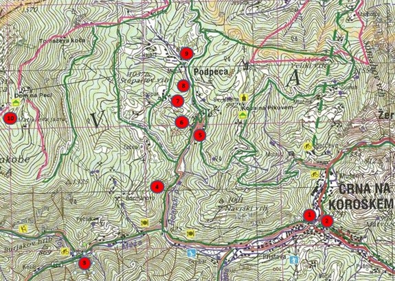
- ETNOGRAPHICAL COLLECTION (Centre of Črna) - 573.34 m
- MINING COLLECTION (Centre of Črna) - 578.00 m
- INFO POINT GEOPARK KARAVANKE (TIC Topla) - 689.69 m
- PERKMANDELJC - 751.13 m
- MINING COLLECTION IN HELENA - 795.65 m
- MONUMENT OF MINER - 802.63 m
- ENTRANCE IN THE TUNNEL HELENA - 802.63 m
- /
- CASTLES OF KING MATJAŽ - 899.20 m
- HORSEBACK CLUB KROFLA
- CAVE OF KING MATJAŽ - 1638 m
ČRNA NA KOROŠKEM: 586 m above sea level
NAJEVSKA LIME TREE: 1056 m above sea level
ALTITUDE DIFERENCE: 470 m
WALKING TIME: 2 h
From the centre of the village we head west in the direction of Koprivna, past the bank to the stone bridge across Meža. We do not cross the bridge but walk few meters on the left side of the stream. Right behind the third house (Center 43) we leave the road, cross a field and get to the chart track under the cementery. We continue on this path until we get to the water distribution system. Here we look for a trail to the left which rises slightly above the chapel to the into the Rešer hill. When we see the view of the centre of Črna we must continue to climb to the right to the edge of the forest and follow it to the top of the hill. Above us we can already see the farm Kogelnik. The blazes lead us through the courtyard of the farm to a forest path from which we get to a macadam road which leads us from Črna to Najevska lime tree. To the left just a few steps down the road we get to some wooden steps on the right in the side of the road. Above the edge we follow a narrow path through blueberry bushes steeply up the hill and in a while we reach the other forest road. We cross it and again start to climb into the hill which levels out a bit near the top. We get to the mountain pass between the Veselkov top and Staneči top. From here we descent down a steep cart track which brings us out into the open, on a road only a few hundred meters from the lime tree. We follow this road to the Najevska lime tree. The path is easy.
ČRNA NA KOROŠKEM: 586 m above sea level
PIKOVO: 992 m above sea level (hut)
ALTITUDE DIFERENCE: 406 m
WALKING TIME: 1 h
The marked trail starts in Mušenik, 1 km from the centre of Črna towards Mežica. At Grad (Mušenik 7) we turn left from the main road and go west following the side valley on a narrow asphalt road for about 500 m. Before the farmhouse Kordež (Podpeca 15) we leave the road and take a steep driveway path behind the farm which takes us into the hill. The steepness soon ends and the path takes us past the farm Božiček (Podpeca 13) over the field and into the forest. For the next 30 min we climb on a pleasant mountain path which leads us to the road we left under the Kordež farm. We only cross the road and continue on the left path for a few minutes until we get to the church of St. Helen and the lodge on Pikovo.
From the stop at Pikovo we can continue our way to Mitnek in Podpeca which is the starting point for Peca. From the lodge on Pikovo we take a narrow forest road for 20 minutes. The path is easy.
MITNEK: 890 m above sea level
PECA: 1665 m above sea level (hut)
ALTITUDE DIFERENCE: 775 m
WALKING TIME: 2 h 15 min
We start our journey in the parking space at the snack bar at Matjaž. in front of the restaurant the path leads to the left down the road and left into the hill towards the farm "At Erih" Najbrževo. We follow the cart track to the road on which we can continue a few ten meters to the left and the blazes again direct us towards the walking path. We continue by climbing steeply a long way into the forest, cross two more forest roads and we pass by the hunting cabin (The cabin of Nino). Above the cabin the path again leads us on a road which we leave immediately. We continue on a broad forest path for around 45 minutes. A few meters from the mountain lodge on Peca we walk on flat grounds. This path is easy.
SMREKOVEC: 1377 m above sea level (hut)
KOMEN: 1684 above sea level
ALTITUDE DIFERENCE: 307 m
WALKING TIME: 1,5 h
From the lodge on Smrekovec we can continue our path to the top of Smrekovec 1.577 m (30min), to Krnes 1.613 (1hour) or to Komen 1.684 (1,30 hours). From the lodge we rise at the edge of the forest in the northeast direction through a forest and in 15 minutes we reach a small flat ground area where a path turns towards the right, the path to the top of Smrekovec. There is only 15 minutes of unmarked road towards the top. To get to Komen we have to turn west at the crossroads for the top and continue on a flat path, across the overgrown grazing grounds of the Kumpaška mountain. We cross a stream and follow a path that is deeply rooted into the thick soft grass and between the rocks we get to the forest. It is only a short walk in the shade and we are on the main ridge. Wide grasslands of the Kogovnik mountain start here and we cross them quite quickly. In the spruce tree sorest the path starts to climb and after 15 minutes we get to the beginning of the Ramšak mountain. Here we find a crossroads where we can climb onto the east hillside of Krnes in 10 minutes and return back to the marked road to the west. Past Krnes the blazes lead us on the southern hillsides and in a very short time we again reach the ridge between Krnes and Kom. Above the ridge the path climbs very steeply to a flat area on the south side of Komen. It is a 5 minute walk on soft grass to the chapel. The top is only a few steps to the North. This path is easy.